1) most spots were closing out
2) tons of crowds because of the long holiday weekend
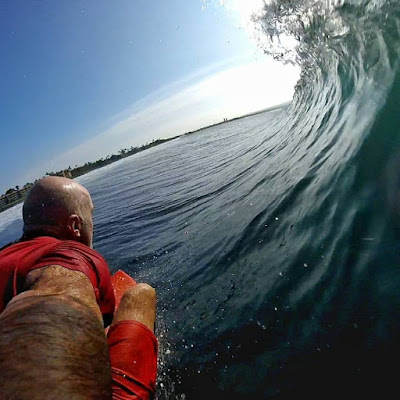
Yesterday instead, both aspects improved a lot (second one only in the afternoon) and I surfed 5+ hours in four different sessions. This is a gopro shot that shows the beauty of the afternoon conditions at Thousand Peaks: a solid 8 due to a bit of texture of a very light onshore wind. Glassy would have been a 9, light offshore a 10. But what made it very special, it was that it was just me and a friend, observing the people on the shore totally surfed out and packing up to go back home early after an "exhausting" three days in a row at the beach. Sometimes you just got to wait. Today and the rest of the week should be even better.

Jason Hall's gopro shots are more exciting then mine.

4am significant buoy readings
South shore
ALL the outer buoys are down (which is an impossible coincidence, so it must be something else), so we have to base our analysis on three things:
1) the WW3 forecast, which in its Surfine implementation today calls for a declining 2.5f 12s at 8am
2) the analysis of the original fetches (done below)
3) the observation of the webcams (when the sun comes out)
Below are the wind maps of May 22 (Monday), 23, 24 and 25. You might have to click on the photo and watch it on a computer screen to see something. I went back 8 days, because the lovely fetch on the 23rd (7 days ago) is a bit further away than usual and I think the related swell it will require 8 days of travel. Accordingly, both Surfline and Pat Caldwell (and me when I saw it a week ago!) call for a new long period pulse starting tomorrow. So for today we're probably gonna surf the slower lower period energy generated by the fetch on the 22nd. Should be another fun day, with much less crowd.

Here we go, in the meantime, the sun did came out and even though the webcam still struggles to keep the focus, this is a killer head high

North shore
Pauwela
2.7ft @ 9s from 37° (NE)
Still small waves at Hookipa, get them clean before the wind gets on it as the sensor is only reading 2(0-4) from ENE at 5am, but today it will pick up at one point. Below is the 5am map that shows it right behind the corner.

This is the 2pm map that shows the wind in the 18-21mph at Hookipa, while the other models predict the return of the trades to only happen later tonight and tomorrow. I already know that this model is going to be right again. It's pretty good for the north shore, I think. Not as good for the south shore unfortunately.

North Pacific wind map shows a few fetches that will make the NW energy picking up tomorrow (3.7f 11s from 332 at 8am is the latest prediction) last a few days.

South Pacific wind map is quite poor from the Hawaii wave generation point of view. I would not expect any of the circled Tasman Sea energy to make it all the way to us, but it's gonna be good for the Fiji WSL contest. Still tons of energy directed to South America.

The clouds are still doing their counter clockwise dance, but they're not creating any damage, so guess what... another absolutely stunning sunny day is on its way. The weather in Hawaii is just ridiculously good.


No comments:
Post a Comment